This was a great hike and overall the trail is in pretty good shape. I took the “Rim of the Valley” trail connecting from the George Deukmejian Wilderness Park. This is probably not the greatest hike in the Summer because you are mostly exposed to the Sun, so, if you do it in the Summer, wear a hat, use Sunblock, and bring lots of water. This hike to Mt. Lukens is strenuous and should only be attempted by Intermediate to Advanced hikers that are in great physical condition. ‘The “Rim of the Valley” trail will eventually connect to the Haines Canyon Truck Trail that will take you all the way to the summit of Mt. Lukens. I did this hike on 12/17/2011 and I saw a lot of people enjoying the trails, but, I did not see many people as I began my ascension towards Mt. Lukens; maybe like 5 or 6 overall. The summit of Mt. Lukens had snow completely covering the trail over the last 1/4 mile or so and it was pretty cold up there, but, the views from the summit are panoramic in every direction. You can get a great view of Catalina Island and beyond. Also, since there are radio towers, most likely, you will have cell reception. There are also several areas where you can rest and have snacks and/or drinks, and enjoy the magnificent views.

Old bridge that was destroyed in a landslide several years ago.
From the Parking lot at the park, you will take a little trail/road that starts by a stone building, and at about a 1/4 mile or so, you will pass an oak tree, and see couple signs. Take the left trail(Rim of the Valley), and, then a make a right when you come to a section where you can either go right or left. As you begin this first climb, just continue to stay right and eventually, in about 1/4 mile or so, the trail will take you to the right and down to a stream where you will pass an old concrete sort of bridge. The trail will then take you to the left, and, soon you will start climbing again where you will pass a collapsed bridge. After the bridge, just a bit further up, the trail will make a sharp right and then you will begin a step ascension of switchbacks towards Mt. Lukens. Continue on the switchbacks and eventually the trail will start heading Northeast. There will be couple of sections where you will do a short but very steep climb, and, on the second section, you will see a wooden post and connect to the Haines Canyon Truck Trail where you will make a right. This truck trail will lead you to the summit, although at this point you will have another 1500 feet or so to climb, this will be more of a gradual ascension. Keep in mind that before you reach the truck trail, the “Rim of the Valley” trail(after the switchbacks) has sections that break off into other trails, so, make sure you are aware of that because on the way back down at this area, I missed a turn and went straight, and when I realized I was going the wrong way, I had to climb back up to connect to the correct trail, and this added about another 200 feet of elevation, so, keep track of your surroundings.

View towards Catalina from near the Summit of Mt. Lukens.
Mt. Lukens Hiking Statistics:
- Elevation Gain – 3000 feet
- Round Trip – 9 Miles
- Suggested Time – 4-5 hours
- Difficulty – Strenuous
- Best Season – Year Around(Just be cautious if there is snow)

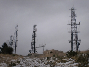
Radio towers at the Summit of Mt. Lukens.
Mt. Lukens is in the Angeles National Forest. From I-210 east or westbound in La Crescenta take the Pennsylvania Avenue exit north to Foothill Boulevard. Turn left (west) on Foothill Boulevard to Dunsmore Avenue. Turn right (north) on Dunsmore Avenue towards George Deukmejian Wilderness Park (City of Glendale). Make a right at Markridge Road, and then make a left at the park sign entrance, proceed for about 1/2 a mile or so, and then park in the lot to your right. Unlimited parking. Just in case, if you have one, display an adventure pass, although I do not think it is needed there.
If you have any additional questions about this hike, feel free to leave a comment here, and/or email me at 412cobrapower@gmail.com


Just took the trail, 12-16-2012. It has been reworked and is in excellent condition. Two runners came up the Dunsmere Trail and said that had been reworked too and was in excellent condition.
That’s great to hear that the trail has been reworked. I am sure that you enjoyed the hike and the awesome views. Thanks for reading the Blog.